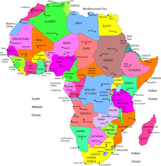
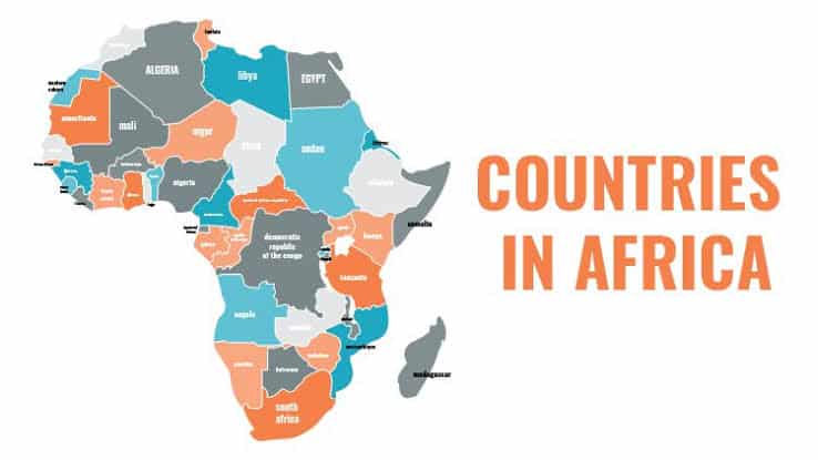
From the sweeping Sahara Desert to the lush rainforests of the Congo Basin, Africa’s vastness is matched only by its complexity. Yet, amidst this rich tapestry, one question often arises: How Many Countries Are In Africa?
In this article, we embark on a journey to unravel the geopolitical intricacies of Africa, exploring its diverse political landscape and shedding light on the number of countries that comprise this vibrant continent. By delving into historical legacies, contemporary challenges, and varying perspectives, we aim to provide a comprehensive understanding of Africa’s political divisions and the factors shaping them.
Join us as we navigate through the boundaries and borders of Africa, uncovering the truths behind its nations, territories, and the remarkable unity that binds this extraordinary continent together.
Understanding Africa’s Geopolitical Landscape
Africa’s geopolitical landscape is a complex tapestry woven from centuries of history, colonial legacies, and contemporary dynamics. To comprehend the number of countries in Africa, it’s essential to explore the continent’s intricate political history and the factors that have shaped its boundaries.
Definition Of A Country
A country, in its simplest form, refers to a sovereign state with defined borders, a government, and the capacity to engage in international relations. In Africa, these entities vary widely in size, population, and resources, reflecting the continent’s diversity.
Historical Context: Colonialism And Its Impact
Colonialism left an indelible mark on Africa, fundamentally altering its political landscape. During the “Scramble for Africa” in the late 19th century, European powers carved up the continent, often disregarding existing ethnic and cultural boundaries. This arbitrary division laid the foundation for many of Africa’s modern-day borders, leading to ethnic tensions and territorial disputes.
Recommended: What Are The American Visa Free Countries?
Evolution Of Africa’s Political Map
The political map of Africa has undergone significant changes throughout history, shaped by colonialism, decolonization, and ongoing geopolitical dynamics. Understanding this evolution is essential for grasping the complexity of Africa’s current geopolitical landscape.
Colonialism And Border Imposition
During the late 19th and early 20th centuries, European powers colonized much of Africa, imposing artificial borders that often disregarded existing ethnic, cultural, and geographical boundaries. This arbitrary division fragmented communities and sowed the seeds of future conflict.
Scramble For Africa
The “Scramble for Africa” saw European powers, including Britain, France, Germany, Belgium, Portugal, and Italy, compete for control over African territories. Through treaties, military conquests, and diplomatic maneuvers, they carved up the continent, claiming vast swathes of land for economic exploitation and geopolitical dominance.
Legacy Of Colonialism
The legacy of colonialism continues to influence Africa’s political map to this day. Many of the borders drawn by colonial powers remain unchanged, despite not reflecting the ethnic, linguistic, or cultural realities of the continent. This has led to internal conflicts, border disputes, and challenges in nation-building.
Decolonization And Independence Movements
In the mid-20th century, Africa witnessed a wave of decolonization as colonies gained independence from European rule. This period saw the emergence of new nation-states as African leaders, inspired by nationalist movements, fought for self-determination and sovereignty. However, the process was not without its challenges, and post-independence struggles for power and resources often led to instability and conflict.
Redrawing Borders And Territorial Disputes
Following independence, some African countries sought to redraw borders to better reflect ethnic, linguistic, or cultural identities. However, attempts to alter colonial-era boundaries have been met with resistance from neighboring states, leading to territorial disputes and tensions. Additionally, the presence of natural resources, such as oil and minerals, has exacerbated competition over contested territories.
Contemporary Dynamics And Challenges
Today, Africa’s political map continues to evolve in response to changing geopolitical dynamics, demographic shifts, and economic interests. Globalization, regional integration efforts, and the rise of non-state actors further complicate the picture, influencing patterns of migration, trade, and security.

Determining The Number Of Countries In Africa
Counting the number of countries in Africa may seem straightforward, but it’s a task fraught with complexities due to various factors, including political disputes, differing perspectives, and the presence of territories with limited recognition. Let’s move into the intricacies of determining Africa’s country count.
Recognized Sovereign States:
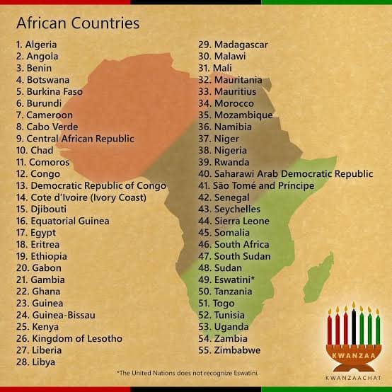
At first glance, Africa is home to 54 recognized sovereign states, according to the African Union. These countries have international recognition, defined borders, and functioning governments. From populous nations like Nigeria and Ethiopia to smaller states like Seychelles and Djibouti, Africa’s diversity is evident in its sovereign entities.
Disputed Territories And Self-Declared States:
Beyond recognized countries, Africa also includes disputed territories and self-declared states that complicate the count. For example, the Western Sahara is a region with a longstanding dispute between Morocco and the Sahrawi Arab Democratic Republic (SADR), which claims sovereignty over the territory. Similarly, Somaliland declared independence from Somalia in 1991 but lacks international recognition as a separate country.
Varying Perspectives On Statehood:
Determining what constitutes a country can vary depending on political perspectives and international recognition. While some entities may be recognized by certain countries or regional organizations, they may lack widespread acknowledgment as independent states. This disparity in recognition adds further complexity to the count of countries in Africa.
Regional Organizations And International Relations:
Africa’s political landscape is also influenced by regional organizations like the African Union (AU) and the Economic Community of West African States (ECOWAS), which play roles in determining membership and statehood. Additionally, international relations and diplomatic efforts can impact the recognition of countries and territories within Africa.
Challenges In Accuracy:
Despite efforts to establish a definitive count of countries in Africa, challenges persist in achieving accuracy. Political disputes, changing borders, and evolving notions of statehood contribute to discrepancies in counting countries. Moreover, the fluid nature of geopolitics means that the number of recognized countries in Africa may change over time.

Exploring Africa’s Political Entities
Beyond recognized sovereign states, Africa is home to a diverse array of political entities, including territories seeking independence and regions with varying degrees of autonomy. Understanding these entities is essential for grasping the complexity of Africa’s political landscape.
Recognized Sovereign States
Africa’s recognized sovereign states, totaling 54 according to the African Union, have international recognition, defined borders, and functioning governments. These countries range from populous nations like Nigeria and Egypt to smaller states like Seychelles and Comoros. Each sovereign state contributes to Africa’s cultural, linguistic, and ethnic diversity.
Territories Seeking Independence
Several territories within Africa have sought independence from their parent countries, often citing historical grievances, cultural distinctiveness, or aspirations for self-determination. For example, the Western Sahara has been the subject of a longstanding dispute between Morocco and the Sahrawi Arab Democratic Republic (SADR), which claims sovereignty over the territory. Similarly, Somaliland declared independence from Somalia in 1991 but has yet to gain widespread international recognition.
Regions With Autonomy
In addition to territories seeking independence, Africa also includes regions with varying degrees of autonomy within recognized sovereign states. These regions may have special administrative status, devolved powers, or cultural autonomy. Examples include Zanzibar in Tanzania, which has its own government and legislature, and the autonomous regions of Bougainville in Mozambique and Casamance in Senegal.
Self-Declared States
Africa also features self-declared states that claim independence but lack widespread international recognition. These entities often emerge from conflicts or political upheaval and operate independently despite lacking official recognition. For instance, the Republic of Somaliland declared independence from Somalia in 1991 and has its own government, currency, and security forces, yet remains unrecognized by the international community.
Implications For Geopolitics
The presence of various political entities in Africa has significant implications for geopolitics, regional stability, and international relations. Disputes over sovereignty, autonomy, and recognition can lead to tensions between neighboring states and complicate efforts to resolve conflicts. Moreover, the status of self-declared states and territories seeking independence raises questions about the principle of self-determination and the role of the international community in mediating disputes.
Recommended: Why You Need Travel Guard
Factors Influencing Africa’s Political Boundaries
Africa’s political boundaries are influenced by a myriad of factors, including historical legacies, ethnic diversity, economic interests, and geopolitical dynamics. Knowing these influences is crucial for comprehending the complexities of Africa’s geopolitical landscape.
Ethnic Diversity And Cultural Complexities
Africa is home to a vast array of ethnic groups, each with its own language, culture, and traditions. The continent’s diverse ethnic makeup has historically played a significant role in shaping political boundaries, with colonial powers often imposing borders that did not align with existing ethnic or cultural divisions. Consequently, many African countries are characterized by ethnic diversity, which can sometimes lead to tensions and conflicts over identity, representation, and resource allocation.
Colonial Legacy And Arbitrary Borders
The legacy of colonialism looms large over Africa’s political map. During the “Scramble for Africa” in the late 19th century, European powers partitioned the continent among themselves, drawing borders that were often arbitrary and disregarded pre-existing political, ethnic, and cultural boundaries. As a result, many African countries inherited borders that do not correspond to the natural geography or historical territories of the indigenous populations, contributing to internal tensions and conflicts.
Economic Interests And Natural Resources
Economic interests and the abundance of natural resources in Africa have also influenced the delineation of political boundaries. Countries rich in resources such as oil, gas, minerals, and arable land may be more economically viable and politically influential, leading to competition over control of these resources and potentially impacting border disputes and territorial claims.
Influence Of Regional Organizations And International Relations
Regional organizations such as the African Union (AU) and the Economic Community of West African States (ECOWAS) play a significant role in shaping Africa’s political boundaries. These organizations aim to promote regional integration, cooperation, and peacebuilding, often mediating disputes between member states and facilitating cross-border collaboration. Additionally, international relations and diplomatic efforts can influence border negotiations, territorial disputes, and the recognition of new states or territories.

Common Misconceptions About Africa’s Political Divisions
Misconceptions about Africa’s political divisions abound, often fueled by stereotypes, misinformation, and oversimplifications. It’s crucial to debunk these myths and gain a nuanced understanding of the continent’s diverse geopolitical landscape.
Misconception 1: Africa Is A Country
One of the most pervasive misconceptions is the belief that Africa is a single country rather than a continent comprising 54 recognized sovereign states. This oversimplification fails to recognize Africa’s vast size, cultural diversity, and complex political divisions.
Misconception 2: Africa’s Borders Are Static And Immutable
Contrary to popular belief, Africa’s borders are not fixed or immutable. They have evolved over time through processes of colonization, decolonization, and ongoing geopolitical dynamics. Border disputes, territorial claims, and efforts to redraw boundaries based on ethnic or cultural considerations are ongoing issues across the continent.
Misconception 3: Africa’s Political Divisions Reflect Tribal Or Ethnic Lines
While ethnic diversity is a significant factor in Africa’s political landscape, it is overly simplistic to assume that political boundaries align neatly with tribal or ethnic divisions. Colonial legacies, economic interests, and geopolitical considerations have often shaped Africa’s borders, leading to the coexistence of multiple ethnic groups within a single country and the fragmentation of ethnic communities across borders.
Misconception 4: Africa Is Homogeneous In Terms Of Governance
Another misconception is that governance structures and political systems are uniform across Africa. In reality, the continent is characterized by a diverse range of governance models, from democratic republics to authoritarian regimes, and from centralized states to decentralized federations. Each country has its own unique political history, institutions, and governance challenges.
Misconception 5: Africa’s Political Divisions Are Inherently Conflict-Ridden
While Africa has experienced its share of conflicts and political instability, it is not accurate to portray the entire continent as a perpetual hotbed of violence and turmoil. Many African countries have made significant strides towards peace, stability, and democratic governance. However, localized conflicts, insurgency movements, and governance challenges persist in certain regions and require targeted interventions to address root causes and build sustainable peace.
Recommended: The Ultimate Guide To Landing Exciting Travel Jobs
Conclusion
The question of how many countries are in Africa unveils the intricate tapestry of the continent’s political landscape. Africa is not merely a monolithic entity but a mosaic of 54 recognized sovereign states, each with its own history, culture, and governance structure. However, beyond these recognized nations lie territories seeking independence, regions with varying degrees of autonomy, and self-declared states, adding layers of complexity to Africa’s geopolitical map.
Understanding Africa’s political divisions requires a nuanced approach that considers historical legacies, colonial legacies, ethnic diversity, economic interests, and geopolitical dynamics. While misconceptions about Africa’s political landscape abound, debunking these myths is essential for fostering a more accurate and informed understanding of the continent.
